Angel’s spit inn and alehouse

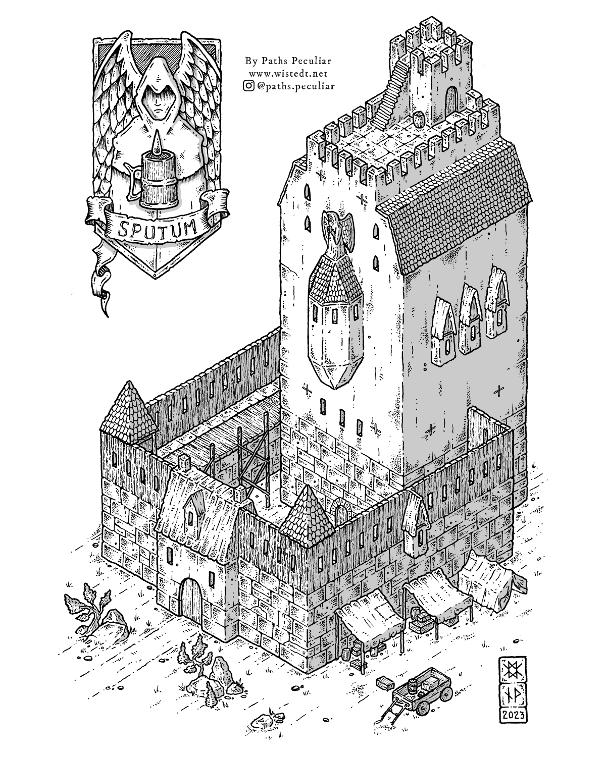
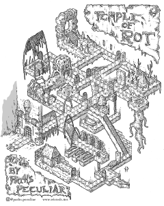
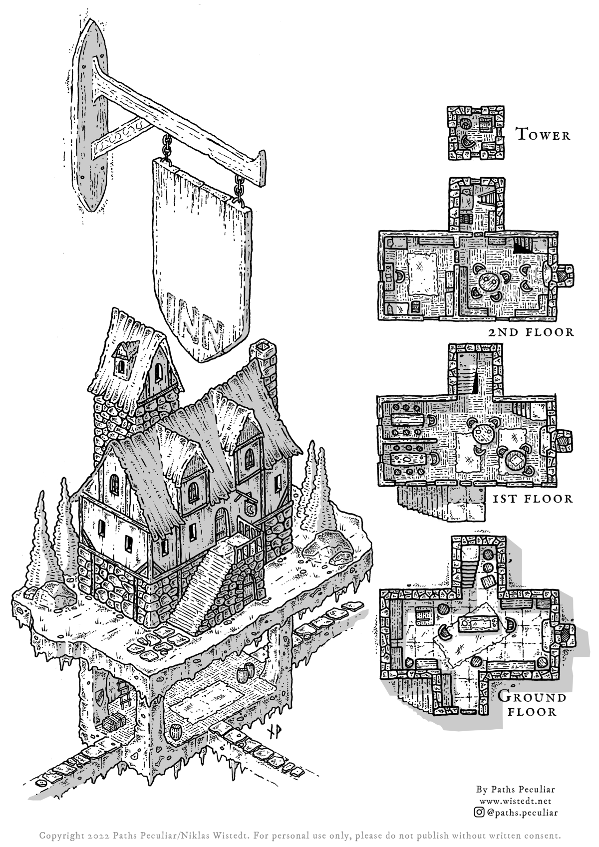
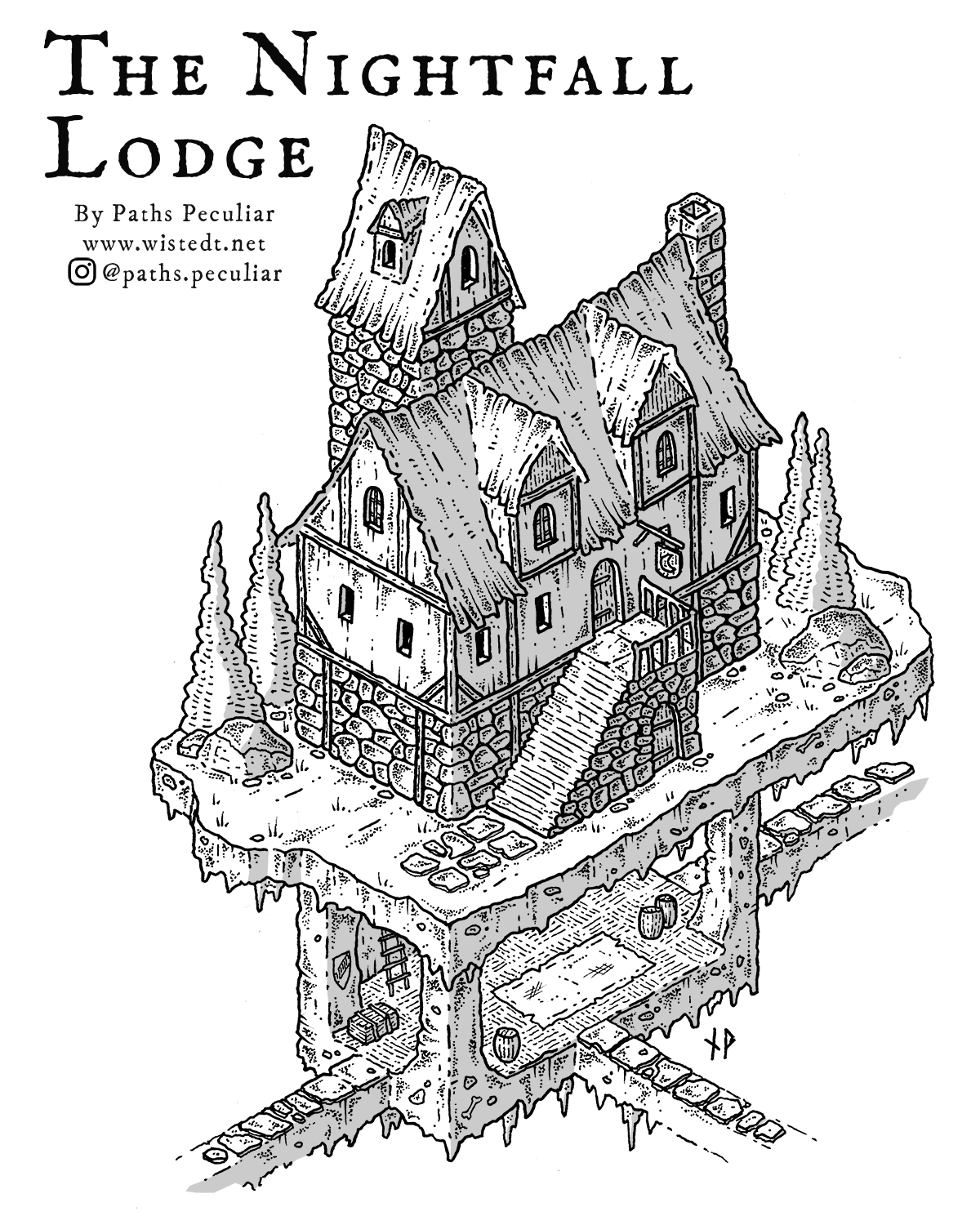
The sturdily built and fortress-like Angel’s Spit inn and alehouse is located on the edge of the borderlands. It is the last homely house before the vast and wild frozen tundra and is frequented by trappers, adventurers, couriers and outdoorsmen.

While the name of the inn might sound peculiar, even off-putting, it was originally meant as a compliment as many years ago an overly-refreshed patron cried out “This ale tastes like the spit of angels!”. The expression stuck, and nowadays few can remember the original name of the establishment.

The Angel’s spit is built like a fort to provide protection against the many dangers that haunt the tundra; raiding orcs, swarms of undead lemmings, giga-mammoths, nekrocapra and more. Still, for all the horrors lurking outside its walls the Angel’s Spit has stood intact for three hundred years and among its patrons many believe this unyielding inn will still be serving ale at the end of times.

Download this map

Feel free to download the Angel’s spit ainn and alehouse map for use in your own campaign. Like everything on this website it’s free for personal use, but I ask you not to publish it without my written permission (I would really like for my content to be exclusive for my own channels).

Support my work

I don’t make a living from my art, but a small tip is always appreciated! If you would like to support me you can either buy me a beer through Ko-fi, or buy an art print here.

Isometric hex map – the ruins at Boulderwood Crags

A potential client asked me if I could draw an isometric hex map, and I realized I don’t know! I’ve drawn plenty of isometric maps, and plenty of hex maps – but never a map with isometric hexagons. So naturally I had to try it out While it started out as an experiment, I decided that I might as well finish it and write something up for you to use in your game. I hope you find it useful!

Boulderwood Crags

The Boulderwood crags is a remote area with few inhabitants. There are both old and truly ancient ruins in the area. Monsters are not uncommon.

Map locations

1. The village of Juniper glade

Juniper glade was likely a nice place in the past, however it is nowadays somewhat glooomy – inhabited only by a handful of very old people. While friendly, the folks of the village know they will be the last to live here and so there is an air of melancholy to the settlement.

2. The tomb of Gulan Tharr

This ancient tomb holds the remains of the barbarian lord Gulan Tharr and his twelve most powerful lieutenants. They died a thousand years ago, but are somtimes up and runing anyway.

3. The tower ruin

This ruined tower was once a prison. Most notable of the previous prisoners was the family of duke Embalan Bredbane. While the duke was hanged for his crimes, his wife and seven children spent the rest of their lives in the tower. There’s still a warden stone golem roaming this area, mistaking innocent passer-throughs for escaped convicts.

4. The ravine

The ravine that runs deep through this area is the nesting grounds for giant centipedes. Super creepy and dangerous bugs. A wise old woman lived in the cabin. She knows how to fend off the centipedes.

5. The dormant portal

The portal used to grant access to several different dimensions, however have been inactive for five hundred years or so. There are still interdimensional things lurking here that was trapped when the portal went bust. They do not get along well with the denizens of the material plane.

Would you like to use this map?

The isometric hex map is available as a download for you to print and use at your gaming table, but please note that commercial use or publishing elsewhere without my consent is prohibited.

Use the link below to download a high-resolution image file.

Would you like to support me?

I don’t put my work behind paywalls, as I like the thought of as many people as possible using it to play games with their friends. That said, if you want to support me please consider a small tip through my Ko-Fi account.

The Bogpike Tower – isometric fantasy tower map

The Bogpike Tower settlement is build in and around the remains of an ancient bridge abutment. To get away from the horrors of the swamp, the inhabitants of the village have added walkways, huts and houses to the sturdy stone structure.

In my own campaign environment of Fourtower Bridge/Western Thistlemoor, the Bogpike Tower settlement is located in western Greenbottle Morass and is a point of light in an otherwise bleak part of the moor. Here are some other examples of how you can use it in your own campaign:

  • A pirate and/or smuggler’s lair
  • A wizards tower
  • A trading post
  • A large inn
  • A fishing village
  • A rebel camp

In any case, I hope you enjoy the tower!

Would you like to support me?

I don’t put my work behind paywalls, as I like the thought of as many people as possible using it to play games with their friends. That said, if you want to support me please consider a small tip through my Ko-Fi account.

Download this map for free!

This map is available as a download for you to print and use at your gaming table, but please note that commercial use or publishing elsewhere without my consent is prohibited.

Use the link below to download a high-resolution image file.

Stick around for a while

Like my work? There’s lot’s of it available on the website. Here are some of the most recent posts:

The Temple of Rot – isometric dungeon map

Oh man, this map took a loooong time to draw, so I really hope you enjoy it. There’s no written story to this dungeon, but perhaps you find the visual storytelling inspiring enough to come up with your own adventure? If you do, please tell me about it in the comments!

Like many of my adventure site maps, this has a dark fantasy streak to it. I like to mix up fantasy and horror elements both in my art and when I run Dungeons & Dragons adventures. I just love it when the players gets a little bit freaked out by the environment.

Would you mind supporting my work?

I don’t like the idea of hiding my work behind paywalls like Patreon and such, and I probably never will. I’m truly inspired by the thought of people around the world enjoying my art, using it when playing games and having fun with their friends. That said, this piece took a lot of effort and time, and if you find it valuable please consider a small tip through my Ko-Fi account.

Download this map for free!

Wether you tipped or not, the map is available as a download for you to print and use at your gaming table! (but please note that commercial use or publishing elsewhere without my consent is not ok)

Use the link below to download a high-resolution image file.

Like my work – why don’t you stick around for a while?

There are loads and loads of tabletop rpg and D&D content on this website, so if you enjoy browsing like it’s the nineties, here are a few links to my latest posts! 🙂

The Rook Tower – isometric illustration of a wizard’s tower

Originally constructed three-hundred years ago by the late wizard Belfador, “the Tower of the Four Avians” is commonly referred to as “Rook Tower” due to the large colony of rooks that inhabit the old spire. The tower is located north of Fourtower Bridge, at the base of the mountains overlooking the moorland.

The rooks of the tower

The rooks of the tower have lived there for generations. They are intelligent, and quite vicious birds that have effectively warded off any attempts to occupy the tower. Brigands as well as adventurers have tried taking the tower by force, but none have so far been able to stomach more than a night or two in the tower. The rooks employ various tactics ranging from petty theft to proper terrorization of intruders.

A work in progress

Rook tower is an idea that I’ve had for some time. It is loosely inspired by “Claws from the Night” by Fritz Leiber, and of course to some extent by Hitchcock’s “The Birds”. This is my first illustration for the adventure, and I will (hopefully) soon draw maps for the interior of the tower. As I work further on the adventure, any updates will be posted here.

More maps – more adventures

If you enjoy my work, why not hang around for a bit and browse like it was 1996? Here are a few of my latest posts:

Medieval fantasy inn map

Since my map of the Nightfall Lodge became quite popular I though I’d expand a bit on it and create a “template” inn map. Use it to create your own inn, tavern or lodge for your fantasy campaign.

I’ve added top-down maps/floor plans for the floors above the surface. Whatever is going on below you’ll have to come up with on your own 🙂

Feel free to download and print this map. I’ve intentionally left some blank space on it for you to add your own notes. The sign is also left empty for you to fill in with a hairy pig, drunken beaver or whatever other colorful representation you want to give your inn.

Free download link

Here’s the download link. The file is a 300 dpi png image in a4 format, so should be quite suitable for printing.

Support my work – buy me a beer

If you like my stuff and want to give me a tip to cheer me on, please click the button below. I don’t make a living on drawing (I wish!), so don’t feel comitted to do so, though. I use the tip I get either for art supplies, supporting other creators or a beer or two at the local pub.

The Nightfall Lodge – isometric inn map

The Nightfall Lodge – an inn deep in the woods, far from civilization. It’s a strange place, this twilight tavern. A candlelight cantina that seems to exist in a perpetual state of evenfall.

Perhaps located in the dense forest west of Drowner’s Lake in Western Thistlemoor, the Nightfall Lodge is a secret to most, yet so many have a faint memory of visiting it.

Have you ever been hopelessly searching for that bar you were almost certain would be just on the corner of that street you can’t seem to remember the name of? You undoubtedly recognize the general area, and you’re almost certain you’ve been here before. That street sign seems so familiar, and you recall clearly the sloping alley snaking its way down to a … square? Or do you really? The more you try to focus on the memory of the Nightfall Lodge, the more blurry it gets.

That’s the magic of the inn of flickering candles. Many have been there, but only once. Previous patrons can’t seem to find their way back, and the more they try the less details they manage to reproduce from their previous visit. You only stumble upon the Nightfall Lodge when you have absolutely no intention of finding it.

Download this map

Feel free to download the Nightfall Lodge map for personal use in your campaign by clicking the link below. Please do not publish my art online or in print without first having my written consent.

More maps, more adventures!

Check out some of my other blog posts, here are the latest ones:

Support my work – buy me a beer

If you like my stuff and want to give me a tip to cheer me on, please click the button below. I don’t make a living on drawing (I wish!), so don’t feel comitted to do so, though. I use the tip I get either for art supplies, supporting other creators or a beer or two at the local pub.

Ancient and Dreadful – isometric dungeon map

There’s something about this design I find unnerving, but I can’t really put my finger on what it is. It just feels … wrong. Ah well, probably just my imagination playing me tricks while I drew it. In any case, here’s an ancient burial site that you can use as a point of interest in your campaign.

There’s probably something nasty down there for the player characters to find. Like the eerie stone carved to resemble a skull. If that thing isn’t cursed then I don’t know what is.

Here’s a download link, feel free to use it in your personal game (like always it’s free for personal use, but I ask you not to publish it elsewhere without my written consent):

More tombs to explore

You know me, I like to draw old and dusty tombs, crypts and burial sites. Here’s a few more:

Perchburrow Point – isometric village map

Perchburrow Point is an old fishing village located at the wind-harrowed Howling Coast. It is (literally) the last point of light before the vast and stormy sea, and whatever horrors await in and beyond it.

The settlement is located on top of a underground system of caves and rivers. As these freshwater rivers meet the ocean the water in the caves is brackish, and there’s an abundance of perch to be caught by veteran fishermen.

Perchburrow Point is an important maritime mark due to the ancient lighthouse that is managed dutifully by the people of the village. Many ships pass by here, and some lay anchor to allow crews a night at the inn before braving the sea (or returning from it).

Please feel free to download the map and use it in your campaign. It should be useful to represent any coastal settlement in a semi-medieval setting.

Like all content on this website this map is free for personal use (I just ask you not to publish it elsewhere without my consent).

Free download (300 dpi .png file)

Support my work – buy me a beer

If you like my stuff and want to give me a tip to cheer me on, please click the button below. Please note that tipping is appreciated, but not expected. Don’t donate if you’re short on cash, I’m sharing content because I like to, not to make money.

Surf the web like it’s 1996! Here’s a list of my latest blog posts

Twinstone Fort – “viking style” great hall

Here’s an isometric map of a “viking style” fort that you can use in your campaign. Feel free to use the background story below, or just make up your own!

Earl Birger the Bloodnose

The great earl (or “jarl”) Birger the Bloodnose got his ephitet after surviving a mace blow to the face, leaving it permanently bloodshot and deformed (the incident also made him forever prone to sudden bursts of nosebleed when excited).

Despise his grim visage, Birger is a fairly good-hearted man. His twelve hirdmen respect him and nearby farmers find him fair and just. The few shield-maidens as well as the seers have acknowledged the Bloodnose’s right to rule. Even Birger’s thralls recognize that they could be considerably worse off.

In terms of standing manpower Birger is one of the less powerful earls in the country. However, by fair treatment of the beforementioned groups he has managed to form a strong bond to his people. This bond has proven exceptionally useful when the need to quickly muster fighters arise.

Even though Birger is in his fifties he is unmarried, and has no children. His three older sisters live with him. They are also unmarried.

Birger the Bloodnose is a ninth level fighter with the title of "Lord" (D&D B/X).

Twinstone Fort

The fort is named after the two ancient runestones located just outside the gates. The stones tell the story of twin brother and sister who slew a vicious wyrm on the small motte now housing the keep tower.

The wooden pallisade is sturdy enough, as is the newly built watchtower. The gates are closed at night, but usually open during day hours.

Birger Bloodnose is a man of tradition, and will welcome travellers into his great hall. As tradition dictates guests will always be offered food, ale and a place to sleep. Adventurers, especially bards, are appriciated guests.

Free download (300 dpi .png file)

Support my work – buy me a beer

If you like my stuff and want to give me a tip to cheer me on, please click the button below. Please note that tipping is appreciated, but not expected. Don’t donate if you’re short on cash, I’m sharing content because I like to, not to make money.

In the mood for browsing? Here are my latest blog posts: